2004-07-29
DARFUR na Wikipedia
Darfur Sudão 
 Tableof contents
1 Geography
2 Economy and Demography
3 History
3.1 The Darfur crisis
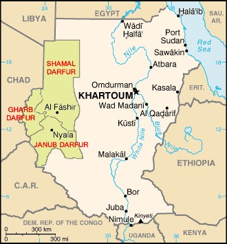
Geography
Darfur covers an area of some 196,555 km² (75,890 miles²), with an estimated population of around 3.1 million people. It is largely an arid plateau with the Marrah Mountains (Jebel Marra), a range of volcanic peaks rising up to 3,000 m (10,100 ft), in the centre of the region. The north comprises a sandy desert, while bush forest exists in the south. The region's main towns are Al Fashir and Geneina.
...
 Tableof contents
1 Geography
2 Economy and Demography
3 History
3.1 The Darfur crisis
Geography
Darfur covers an area of some 196,555 km² (75,890 miles²), with an estimated population of around 3.1 million people. It is largely an arid plateau with the Marrah Mountains (Jebel Marra), a range of volcanic peaks rising up to 3,000 m (10,100 ft), in the centre of the region. The north comprises a sandy desert, while bush forest exists in the south. The region's main towns are Al Fashir and Geneina.
...
Comments:
<< Home
Cada vez gosto mais deste blogue. Tb eu costume consultar esta enciplopédia, e lá encontrei o significado de "Desenrrascanço" como sendo palavra portuguesa, fiz até um post da altura sobre isso.
Beijinho, e boas férias se for o caso
Enviar um comentário
Beijinho, e boas férias se for o caso

<< Home
![]()


